Andrew J. Lewis, PhD
Communities inherit landscapes. They come to know themselves by learning how to move through them together.
Executive Summary
The Town of Somerset occupies a distinctive position within Montgomery County, Maryland. Much of the town developed on higher ground between two stream branch corridors: the Willet Branch valley to the west and the Little Falls Branch valley, now preserved as Vinton Park, within the town itself. Together these landscapes have shaped the character of Somerset for over a century. That landscape influences where streets end, where trails begin, how residents move between neighborhood and parkland, and how everyday civic life unfolds at the meeting of built and natural landscapes. Many discussions about streets begin with traffic, intersections, or individual infrastructure projects. This report begins one step earlier. It asks how Somerset came to occupy this landscape and how that history continues to shape the town today.
Seen from this perspective, questions about sidewalks, accessibility, trail connections, and public space become part of a larger civic story. They are not simply engineering questions. They reflect the relationship between a community and the landscape it has inherited.
This report examines the historical, geographic, legal, and institutional context that has produced Somerset’s present-day Pedestrian Ecology. Its purpose is not to advocate for a particular infrastructure project, but to provide a common frame of reference for understanding how landscape, civic life, and public infrastructure interact.
Whether future decisions involve sidewalks, traffic calming, painted walking areas, or no physical changes at all, they will be stronger if they begin with a shared understanding of the place itself.
Introduction
Before considering transportation, public policy, or infrastructure, it is worth pausing to look at the landscape.
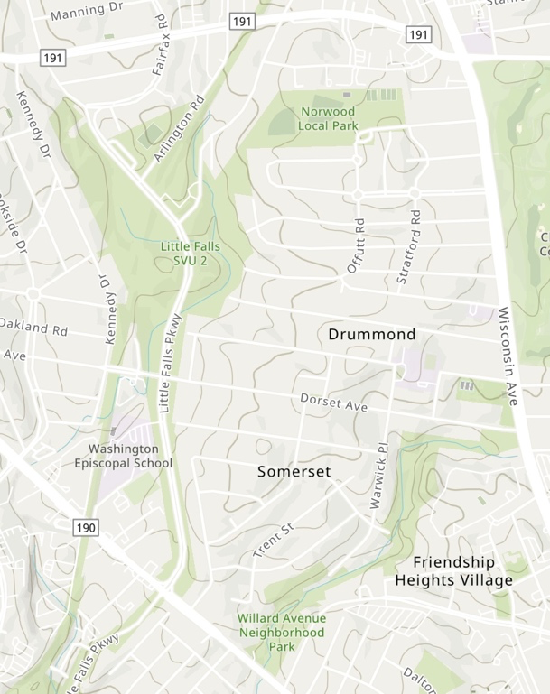
Somerset occupies an unusual position within Montgomery County. The town developed on higher ground between two stream corridors. To the west, the land falls toward the Willet Branch corridor. Within the town itself, Little Falls Branch passes through what is now preserved as Vinton Park before continuing south.
To the north and east, Somerset blends almost seamlessly into the older residential neighborhoods of Drummond and Chevy Chase Village. To the south and southeast, it meets the increasingly urban landscape of Friendship Heights and the former GEICO campus, now being redeveloped at much greater density.
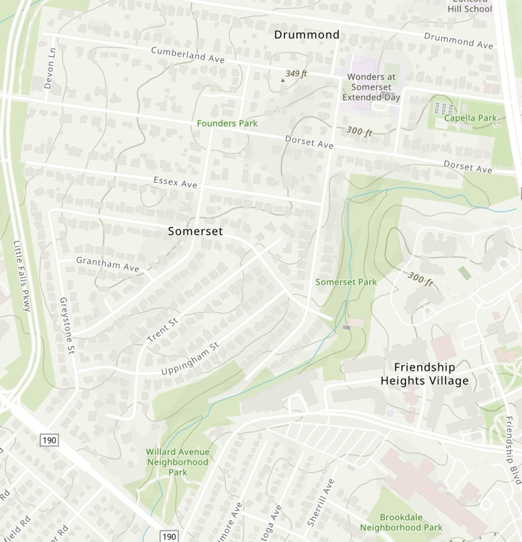
Between these very different landscapes lies the familiar geometry of Somerset itself: homes, streets, sidewalks, schools, and the civic infrastructure characteristic of an early twentieth-century suburb. Together, these relationships define the setting within which the town developed.
Many of the questions Somerset faces today emerge from this geography. Questions about walking, trail access, neighborhood streets, public space, and accessibility did not appear in isolation. They developed over time as the town evolved alongside a landscape that earlier generations deliberately chose to preserve.
Understanding those questions therefore begins not with a particular street or proposal, but with the place itself.
The Valley Before the Town
Long before Somerset’s streets were surveyed, the landscape that now defines the town had already established its own logic.
Willet Branch, Little Falls Branch, and countless similar streams carved the valleys that would later become suburban Montgomery County. Water shaped wooded slopes, tributary ravines, and natural corridors that directed movement through the landscape long before human-imposed streets, property lines, or municipal boundaries.
When suburban development reached this area during the early twentieth century, planners faced a choice confronting many growing metropolitan regions. They could impose an uninterrupted street grid upon the landscape, or they could allow neighborhoods to adapt to the geography already present.
In the Washington region, an important decision emerged.
Beginning in the late 1920s, the Maryland–National Capital Park and Planning Commission began preserving stream valleys throughout Montgomery County. Rather than treating creeks as obstacles to development, planners viewed them as permanent public landscapes that could serve ecological, recreational, and civic purposes simultaneously.
The Little Falls corridor became part of that larger vision.
What appears today as wooded parkland bordering Somerset is therefore not undeveloped land left behind by suburban growth. It reflects a deliberate planning decision made nearly a century ago: to preserve the landscape while allowing surrounding neighborhoods to develop beside it rather than over it.
Somerset did not simply acquire parks.
It grew alongside a landscape that has continued to shape the town ever since.
Living at an Edge
That early planning decision continues to shape everyday life in ways that are easy to overlook.
Many suburban neighborhoods are organized around streets. Parks occupy individual blocks or exist as destinations reached by car.
Somerset is organized differently.
The town’s relationship with the surrounding landscape is never far away. To the west, neighborhood streets approach the Willet Branch stream valley. Within Somerset itself, Vinton Park preserves the Little Falls Branch corridor that quietly shapes the town from within. Streets approach the wooded valley and often stop. Small paths connect residential blocks to regional trails. Within a few minutes’ walk, the sounds of neighborhood life give way to running water, birdsong, and mature woodland.
The transition is so familiar that it often becomes invisible.
Yet it influences how residents experience the town.
An evening walk may continue into the woods. A child exploring a trail enters a landscape protected generations before they were born. Neighbors encounter one another not only on sidewalks but at trailheads, stream crossings, and woodland paths.
These are not simply recreational opportunities.
They reflect a community whose civic life has developed alongside a preserved landscape.
Understanding Somerset therefore requires more than describing streets or cataloguing parks.
It requires understanding the relationship between them.
The Public Landscape
No single institution created the landscape surrounding Somerset, and no single institution governs it today.
The Town of Somerset exercises authority over its municipal streets and plays the primary role in determining how those streets function. Beyond those streets lies a broader public landscape assembled over nearly a century through the work of many different public institutions. Stream valleys, regional trails, public rights-of-way, environmental protections, accessibility standards, and state transportation law each contribute to the way residents experience the town.
To someone walking through Somerset, however, these distinctions are largely invisible.
A neighborhood street becomes a trail.
A sidewalk gives way to packed earth.
A small bridge crosses a stream without announcing which public agency maintains it.
From the perspective of everyday life, the landscape functions as a continuous whole.
Public institutions necessarily divide responsibilities.
Residents experience continuity.
The landscape people experience is singular. Responsibility for caring for it is shared.
Shared Streets, Different Journeys
Maryland law recognizes a practical reality shared by many communities. When sidewalks are absent or incomplete, pedestrians continue to possess the right to move through public space. Residential streets therefore become shared environments in which people walking, cycling, driving, or using mobility devices occupy the same landscape under a common legal framework.
Law establishes rights and responsibilities.
It does not establish a common experience.
A confident adult taking an evening walk, a child riding a bicycle, a parent pushing a stroller, an older resident with limited mobility, and a person using a power wheelchair all move through the same street under different physical conditions.
The available space to maneuver, the ability to respond to approaching traffic, and the consequences of an unexpected encounter differ from one person to another.
The street itself has not changed.
The relationship between the street and the person moving through it has.
For that reason, two residents may describe the same street quite differently without either description being inaccurate.
Each is describing a different experience of the same place.
Understanding those differing experiences does not determine what changes, if any, should be made.
It does suggest that communities benefit from understanding how public space is experienced before deciding how it should evolve.
Learning to Read a Street
Most people read a street for a practical purpose: getting from one place to another.
Transportation engineers notice lane widths, drainage, turning radii, visibility, and traffic volumes. Environmental scientists notice tree canopy, stormwater, and habitat. Residents notice neighbors, familiar walking routes, children riding bicycles, and places where conversations naturally begin or end.
Each perspective reveals something. None reveals everything.
Communities sometimes discover that they are not yet disagreeing about solutions. They are still learning how to describe the same place.
Shared observation matters.
The more clearly a community understands the landscape it shares, the more effectively it can discuss how that landscape should evolve.
The Places Between
Public discussions about infrastructure naturally focus on streets, sidewalks, intersections, and trails.
Yet many of the most important pedestrian experiences occur somewhere else.
They occur where one system gives way to another.
Where a sidewalk ends.
Where a neighborhood street approaches a trail.
Where pavement becomes packed earth.
Where the edge of a park begins.
These transitional spaces belong fully to neither transportation infrastructure nor park infrastructure. They are simply the places where one public landscape becomes another.
Historically, the stream valley parks preserved throughout Montgomery County were intended to remain connected to the surrounding neighborhoods. Small paths, informal openings, and visual connections allowed residents to move naturally between streets, trails, and woodland.
Over time, those transitions evolve.
Infrastructure changes at different moments and under different priorities. Sidewalks appear on one block but not another. Trails remain while surrounding neighborhoods change. Different institutions assume responsibility for different pieces of the landscape.
Residents, however, continue to experience one place.
Many of Somerset’s contemporary questions about movement arise within these transitional spaces. They emerge not only from streets or trails themselves, but from the points where those systems meet.
A Somerset That Flows
Every community inherits a landscape.
Some inherit rivers. Others inherit mountains, coastlines, forests, or open plains. Somerset inherited the edge of two stream valleys—a landscape that earlier generations deliberately chose to preserve as part of everyday community life.
That inheritance continues to shape the town today.
It shapes where streets end.
Where trails begin.
The routes children take to explore the woods.
The paths neighbors follow on evening walks.
The ways residents move between home, school, park, and forest.
The questions that arise from this landscape are therefore not simply questions about transportation.
They are also questions of stewardship.
How should a community care for the landscape it has inherited?
How should public institutions work together where their responsibilities meet?
How should residents with different experiences share the same public spaces?
Reasonable people will answer those questions differently.
Every decision involves tradeoffs.
Every community must balance competing priorities.
Those conversations are inevitable. They are strongest when they begin with a shared understanding of the place itself. Whatever choices Somerset makes in the years ahead, they will be stronger if they begin with a shared understanding of the landscape that has shaped the town for nearly a century.
The planners who preserved the Willet Branch and Little Falls Branch valleys left Somerset with an unusual inheritance: a neighborhood whose civic life continues to unfold where suburb and forest meet.
Each generation receives that inheritance.
Each generation decides how it will care for it.
Conclusion
Somerset cannot be understood solely through its streets, nor solely through its parks.
Its character emerges where the two meet.
The town occupies a distinctive position within Montgomery County: a residential community whose everyday civic life unfolds along one of the region’s earliest preserved ecological corridors. Its public spaces reflect nearly a century of planning, stewardship, and adaptation by institutions and residents alike.
Understanding Somerset requires more than an inventory of infrastructure. It requires understanding the relationships among landscape, history, public institutions, and everyday movement.
Questions about sidewalks, accessibility, trail connections, and public space will continue to evolve, as they should. Communities change. Infrastructure ages. New needs emerge. Future residents will almost certainly make different choices than those who came before.
What should endure is not any individual engineering solution.
It is the habit of understanding the place before deciding how it should change.
Communities inherit landscapes. They steward them with infrastructure.
In time, they come to know themselves through the ways they move together within them.
Selected References
Alexander, Christopher, Sara Ishikawa, and Murray Silverstein. A Pattern Language. New York: Oxford University Press, 1977.
Jacobs, Jane. The Death and Life of Great American Cities. New York: Random House, 1961.
Maryland Code. Transportation Article, §§ 21-502 and 21-506. Current edition.
Maryland–National Capital Park and Planning Commission. Annual Report. 1931.
Maryland–National Capital Park and Planning Commission. Stream Valley Park Acquisition Program. 1963.
Montgomery County Department of Transportation. Complete Streets Design Guide. 2018.
Montgomery County Government. Vision Zero Action Plan. 2017.
Scott, Mel. American City Planning Since 1890. Berkeley: University of California Press, 1969.
Spirn, Anne Whiston. The Granite Garden: Urban Nature and Human Design. New York: Basic Books, 1984.
About the Author
Andrew J. Lewis, PhD, is a writer and founder of The Coherence Portfolio, an independent research and design studio that develops products that help communities, institutions, and adaptive systems learn from lived experience over time.